Canadian Rockies Panorama West of Calgary
© 2018 by Ben Gadd. All rights reserved.
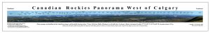
To download the panorama, which is 61 cm long by 7.6 cm wide (24 x 3 inches), click here. You may download it for your own, noncommercial use, at no charge.
The file is about a megabyte in size. It’s a PDF. To print a full-size copy of your own, again strictly for noncommercial use, save the file on a flash drive and take it to an office-supplies or photo shop. If you like, they could print the image even larger for you, to a maximum of double in size. Beyond that you may find the mountain background getting too grainy.
The goal of this project was to produce a photographic panorama of the mountain front west of Calgary and annotate it accurately with the names of the peaks. Here is how I did it.
- On June 27th, 2016, early in the day for the greatest clarity, I used my Panasonic “Lumix DMC FZ200” digital camera to take a series of telephoto images of the mountain front from the Muller Windsports paraglider/hang-glider launch area at the crest of the big hill above Cochrane, Alberta, GPS location N51.19410° W114.44682°.
I stitched these images together right in the field, using my laptop computer and Photoshop, to produce the panorama. It was 6.85 metres long (269.6 inches) and 38.6 cm wide (15.2 inches) at a resolution of 180 dpi.
- That same morning I used a rented Nikon NE-101 theodolite (like a surveyor’s transit but with a more powerful telescope for more distant shots) from Cansel in Calgary (403-243-1836) to take bearings from this location, which I called “Muller Station,” to each summit.
Rather than trying to orient the instrument to true north in the field, which would have been impractical, I sighted on Banded Peak, an easily identifiable mountain with a pointy summit, and reset the instrument’s azimuth to 0.0. Later I corrected these relative bearings to true bearings, meaning degrees from true north.
- I field-annotated each of the relative bearings directly on the panorama by means of the InDesign layout program. I also wrote each figure down by hand for backup. These bearings could be used with Google Earth to see which peaks they intersected. (See step 5.)
I entered the bearings in grads, not degrees. The theodolite would give readings in degrees, but not in decimal degrees. It read in minutes and seconds only. This was not convenient for converting to decimal degrees, which Google Earth used for displaying bearings. Grads are easy to convert to decimal degrees: just multiply by 0.9 exactly.
Having taken as many bearings as I could before the sun swung around and the mountains became too back-lit to pick out the summits with confidence, I marked the exact theodolite location with a large nail pushed into the soil. Bright-green flagging tape was attached to the nail. (After I was sure that I wouldn’t need to set up a theodolite there again, the nail was removed.)
Not requiring any more bearings, I packed up the theodolite and returned it to Cansel. The cost was $120 per week including tripod. The fieldwork had taken only a morning, but I had to rent the instrument ahead of time and await good weather. I had to wait four days.
- Back home, I corrected the relative bearings in grads to true bearings in degrees (0.0 at true north).
First I converted each relative bearing in grads to decimal degrees (multiplied by 0.9). Then I noted the bearing to Banded Peak in Google Earth. This was a true bearing of 212.16 degrees. So I added 212.16 to each of the relative bearings. If a result was over 360 degrees, I subtracted 147.84 degrees, which is 360 minus 212.16.
- With all the relative bearings corrected to true bearings, I could now use Google Earth to draw a line from Muller Station, entered as a “placemark,” along each bearing I had accurately taken through the theodolite’s 30-power telescope and see which peak the line led to. (All the officially named peaks were shown in Google Earth, and some unofficial ones, too.) I then went back to the panorama and updated the bearings with the names.
This turned out to be more difficult than I had thought, because the peaks were not in a single line. There were up to five lines of peaks along parallel ridges that stood in front of one another. In some places a single massif could have several named summits. The theodolite readings were accurate enough to let me pick out most of the peaks with confidence, but several were troublesome. Luckily I had an extra set of photos taken at maximum telephoto power that helped me to resolve these problems. When driving to Calgary I would stop and view the peaks from varying distances and angles, which also helped.
I wanted to post a version of the panorama that anyone could download quickly and view at no charge. Clearly, the full panorama was much too large and detailed for this purpose, so in September of 2016 I used InDesign to produce a smaller, less detailed version.
I sent a draft of this panorama to Dave Birrell, author of 50 Roadside Panoramas in the Canadian Rockies (Rocky Mountain Books, 2000). Dave is also the author of several excellent phone apps for identifying peaks and listening to audio about them. He founded and continues to maintain the authoritative website Peakfinder.com. Dave was kind enough to review my draft panorama. He noted a couple of errors, subsequently corrected. The finished version was first posted to my website on September 20th, 2016.
- The story is not quite over. In March of 2017, after the panorama had been out for a while, I met with Dave Birrell, Lonnie Springer, Aaron Springer, Ed Hergott, Laureen Harper and Dave Albano at the home of Gillean and Tony Daffern in Calgary to compare notes on the names of the peaks seen from west of Calgary. We spent a pleasant morning doing that, and it resulted in a few minor changes to the panorama.
Enjoy!